
About this walk
This is the Blencoe Falls end of the Wet Tropics Great Walk in Girringun National Park, far inland from Cardwell: the track between Blanket Creek walkers' camp, on the Herbert River, and the top of the Herbert River Gorge beside Blencoe Falls. This section runs from Blanket Creek camp west and up to the falls. A short further piece continues towards Blencoe Falls camping area, where the walk starts.
This route is the Jambal walk: Blencoe Falls camping area to Blanket Creek walkers' camp, 21 km return over 2 days, Grade 5, for experienced and self-sufficient hikers only. It is also the first day of the Juwun walk, which carries on 44 km one way through the gorge to the Yamanie pick up point, with no formed track at all beyond Blanket Creek. Blencoe Falls is the gateway to the Wet Tropics Great Walk and its 110 km of walking.
What you walk through
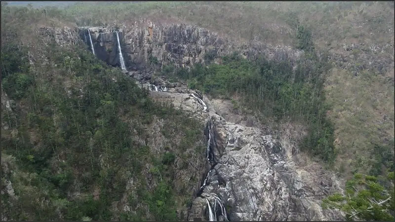
The track leaves from an information sign south east of the camping area and crosses dry open forest before a final steep descent into the Herbert River Gorge, where the banks are shaded by she-oaks. In the dry season the country is parched and many trees drop their leaves; in the wet it floods and turns green again. Look for emus and kangaroos, and listen for kookaburras and sulphur-crested cockatoos. Blencoe Falls itself plunges 90 m into a pool and then cascades another 230 m to the floor of the gorge. The Blencoe Falls lookout and Herbert River Gorge lookout are a short walk from their own car park, 5.2 km off the main road.
Camping and water
There is no reliable water on the way until Blanket Creek, so carry the whole day's supply. Blanket Creek walkers' camp is a shady she-oak site beside the river with no toilets and no campfires. Blencoe Falls camping area has non flush toilets but no drinking water; you can collect water from Blencoe Creek and treat it. All camping needs a booked permit with fees. Pets are not allowed in Girringun National Park.
Getting there
Blencoe Falls is 84 km north west of Cardwell by the unsealed Kirrama Range Road, or reached from Mount Garnet by Gunnawarra and Kirrama to Cashmere roads. Use a 4WD and only in dry conditions, as Cashmere Crossing and the Blencoe Creek bridge can flood from December to April.
Before you go
The Jambal and Juwun walks close every wet season, typically 1 December to 31 March. Estuarine crocodiles live in the Herbert River Gorge, help can be hours away, and mobile coverage is poor, so carry a satellite phone or personal locator beacon. Check the Queensland park alerts and read the Juwun and Jambal walking notes and Blencoe Falls safety page before you go.
Elevation
- Climb
- 650 m
- Descent
- 250 m
- Highest
- 631 m
- Lowest
- 128 m
Approximate, from a 30 m terrain model, so it can overstate the climb on cliff edge tracks.
Before you go
Tell your people where you are going
Set your route and return time in FriendsFindMe. If you do not check in, the people you trust are sent a text so they know to come looking for you.
Park and state forest boundaries: CAPAD 2024 © Commonwealth of Australia (DCCEEW), CC BY 4.0; © Forestry Corporation of NSW, CC BY 3.0 AU; © State of Queensland, CC BY 4.0; © State of Victoria (DEECA), CC BY 4.0
Walk data: Queensland Parks and Wildlife Service access © The State of Queensland 2025, CC BY 4.0