
About this walk
The Keppel Lookout Trail is a loop in Marysville State Forest, on the hills south of Marysville, that takes in Keppel Lookout and the top and bottom of Steavenson Falls. It is a challenging walk: it climbs through mountain ash and stringybark forest, the track is uneven and steep in places, and there are many stairs. It is one of the Marysville Forest Trails, a set of waymarked walks around the town, each marked with its own emblem.
The route
The walk starts from a car park just off Falls Road, about 2 km before the main Steavenson Falls car park, built when the trail was upgraded in 2022. Walk it anticlockwise. You first cross Robertson Gully, then climb to Keppel Lookout, which looks out over Marysville, the Cathedral Range and down the Acheron Valley. The trail then follows the ridge past Oxlee and De La Rue lookouts to the top of Steavenson Falls, and descends beside the falls to their base. This walk follows that loop from the Falls Road car park. You can also start in Marysville itself and walk up the Tree Fern Gully Walk, which joins the lookout trail.
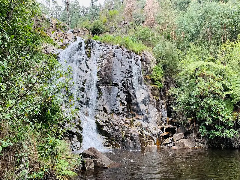
Steavenson Falls is one of the tallest waterfalls in Victoria. It is about 84 to 122 m high, over five cascades. The falls are floodlit from dusk until midnight, powered by a small hydro turbine at the weir below them. The fires of February 2009 destroyed almost all the built facilities at the falls, and the forest around them has regenerated since.
Facilities
Keppel Lookout can also be reached by car on an 11 km return forest drive along Paradise Plains Road, and has a picnic table and a large viewing platform reached by a short flat gravel path suitable for wheelchairs and prams. The trail itself has no reliable water, so carry food, water and wear sturdy footwear. The Steavenson Falls car park has toilets, and parking there costs $3. The nearest accessible toilets to the lookout are at the visitor information centre on Murchison Street in Marysville.
Dogs and alerts
Dogs are allowed on the Keppel Lookout Trail but not at Steavenson Falls, which the loop passes through, so it is best to leave them at home. Check the Forest Fire Management Victoria closures map before you go, and see the Explore Outdoors Keppel Lookout page and Steavenson Falls page for details.
Elevation
- Climb
- 470 m
- Descent
- 460 m
- Highest
- 861 m
- Lowest
- 495 m
Approximate, from a 30 m terrain model, so it can overstate the climb on cliff edge tracks.
Before you go
Tell your people where you are going
Set your route and return time in FriendsFindMe. If you do not check in, the people you trust are sent a text so they know to come looking for you.
Park and state forest boundaries: CAPAD 2024 © Commonwealth of Australia (DCCEEW), CC BY 4.0; © Forestry Corporation of NSW, CC BY 3.0 AU; © State of Queensland, CC BY 4.0; © State of Victoria (DEECA), CC BY 4.0
Walk data: © State of Victoria (Department of Energy, Environment and Climate Action; Department of Jobs, Skills, Industry and Regions), CC BY 4.0