
About this walk
The Overland Track is Tasmania's best known multi-day walk, running south through Cradle Mountain-Lake St Clair National Park in the Tasmanian Wilderness World Heritage Area. It is 65 kilometres from Ronny Creek, below Cradle Mountain, to Narcissus Hut at the head of Lake St Clair, usually over six days, Grade 4. This walk starts at Ronny Creek and carries on past Narcissus along the shore of Lake St Clair to Cynthia Bay, the optional 17.5 kilometre seventh day, with the side trips left out. Almost half the track is above 1,000 metres, on exposed plateaus a long way from help.
The route
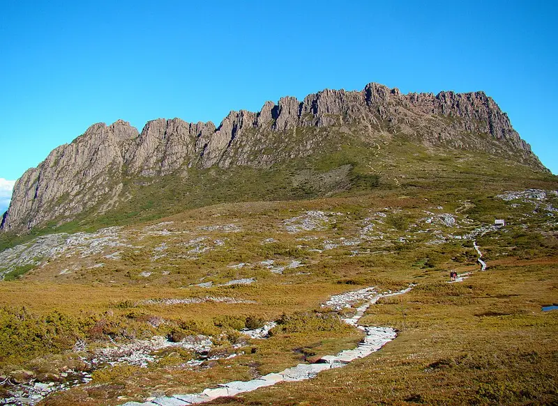
The walk has six stages. Day 1 is 10.7 kilometres, 4 to 6 hours, from Ronny Creek past Crater Lake and up a short, very steep climb to Marions Lookout, then across the alpine plateau to Waterfall Valley. Side trips go to the summit of Cradle Mountain (1,545 metres) and Barn Bluff (1,559 metres), both with boulder scrambling and only for fine weather. Day 2 is an easier 7.8 kilometres over heath, lakes and tarns to Lake Windermere, with a side trip to Lake Will. Day 3 is the longest at 16.8 kilometres, 5 to 7 hours, across buttongrass plains and through myrtle beech rainforest to Pelion Hut, with the 1917 Old Pelion Hut and its swimming hole nearby and Mount Oakleigh as a side trip. Day 4 is 8.6 kilometres beside Douglas Creek up to Pelion Gap, between Mount Ossa and Pelion East, then down to Kia Ora. Mount Ossa, at 1,617 metres Tasmania's highest peak, is a 5.2 kilometre, 4 to 5 hour return side trip from the gap. Day 5 is 9.6 kilometres through rainforest past the 1910 Du Cane Hut, with side trips down to D'Alton, Fergusson and Hartnett falls on the Mersey River, to Bert Nichols Hut at Windy Ridge. Day 6 is a gentle 9 kilometres down the Narcissus Valley to Narcissus Hut, crossing the river on a suspension bridge. Pine Valley Hut, the base for the Acropolis and the Labyrinth, is a side trip from there.
From Narcissus most walkers catch the privately run ferry down the lake, which you must book before you start. Otherwise the 17.5 kilometre lakeside track to Cynthia Bay runs through myrtle beech rainforest, with the small Echo Point Hut about 5 kilometres along.
Huts, water and gear
Each main hut has bunks without mattresses, a composting toilet and a rainwater tank; boil or treat the water. Huts cannot be booked and fill up, so you must carry a tent; most hut sites also have tent platforms. Plan on a pack of about 75 litres weighing about 18 kilograms, carrying at least 2 litres of water. Brushtail possums rip tents and packs for food, so keep food sealed inside your pack, inside your tent. Personal locator beacons can be hired from Service Tasmania shops and, in limited numbers, from the Cradle Mountain and Lake St Clair visitor centres.
Bookings and getting there
From 1 October to 31 May you must book, walking north to south only, with up to 34 independent walkers departing each day. Bookings open on the first Tuesday in July. The fee covers park entry and the shuttle from the Cradle Mountain Visitor Centre to Ronny Creek, and you check in and attend a briefing at the visitor centre before setting out. Outside the season you need a parks pass. Buses run to Cradle Mountain and from Lake St Clair from Hobart, Launceston and Devonport.
Before you go
Snow, rain, strong wind and sun can come in any month, and walk times stretch in blizzards. Read the Overland Track page and its walk notes, and check the Parks and Wildlife Service alerts page before you go.
Elevation
- Climb
- 2,000 m
- Descent
- 2,100 m
- Highest
- 1,271 m
- Lowest
- 739 m
Approximate, from a 30 m terrain model, so it can overstate the climb on cliff edge tracks.
Before you go
Tell your people where you are going
Set your route and return time in FriendsFindMe. If you do not check in, the people you trust are sent a text so they know to come looking for you.
Park and state forest boundaries: CAPAD 2024 © Commonwealth of Australia (DCCEEW), CC BY 4.0; © Forestry Corporation of NSW, CC BY 3.0 AU; © State of Queensland, CC BY 4.0; © State of Victoria (DEECA), CC BY 4.0
Walk data: LIST Transport Segments from theLIST © State of Tasmania, CC BY 3.0 AU