
About this walk
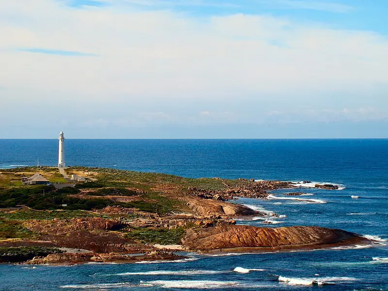
This is the southern end of the Cape to Cape Track in Leeuwin-Naturaliste National Park, the coastal walk that joins the lighthouses at Cape Leeuwin and Cape Naturaliste in the far south west of Western Australia. It starts at the Cape Leeuwin Waterwheel, just north of the lighthouse, and heads north along the coast past Skippy Rock onto Deepdene Beach, stopping partway along the beach a few kilometres short of Deepdene campsite. The rest of the track is in the two sections that follow. The whole track is about 123 to 130 km, and most people take 5 to 7 days.
What you see
The waterwheel was built in 1895 to pump spring water to the lighthouse. It no longer turns, and lime from the water has coated it in stone; it has been on the state heritage register since 2002. Cape Leeuwin Lighthouse, a 39 metre limestone tower, was first lit the same year, and the lightkeepers' cottages now hold an interpretive centre and café. North of the cape the track follows the rocky limestone coast, then drops onto Deepdene Beach, which is long and wild. Soft sand makes it slow going with a full pack. Between May and December humpback and southern right whales pass close to shore, and dolphins can turn up at any time of year. Jewel Cave, one of the region's show caves, is a short drive inland from Deepdene.
Underfoot and markers
The Cape to Cape Track is Class 4: rough surfaces, limited signage, and bushwalking experience and good fitness needed. The southern half has more of a wilderness feel and is harder than the north. Square pine posts carrying a triangular track logo mark the route, with larger wooden signs showing the way off beaches.
Getting there and facilities
The lighthouse is at the end of the road south of Augusta. TransWA coaches run to Augusta, and Augusta Taxis does drop offs at the southern end. There is no vehicle entry fee for Leeuwin-Naturaliste National Park. Deepdene campsite, the first walkers' camp north of the lighthouse, is free and cannot be booked; like the other track camps it has a long drop toilet, a picnic table and a rainwater tank, but no shelter, and the tank water must be treated. Fuel stoves only: no campfires are allowed at the track camps. Dogs and bikes are not permitted.
Before you go
Mobile coverage is poor along much of this end of the track, so leave your plans with someone. Carry at least 2 litres for a day walk, and 4 litres per person per day if you are camping, as tanks can run dry. Summer is hot, with little shade, so do not walk on days of Extreme or Catastrophic fire danger. Check Parks and Wildlife park alerts and the Friends of the Cape to Cape Track alerts before you go. The Explore Parks WA Cape to Cape Track page has maps and safety information.
Elevation
- Climb
- 170 m
- Descent
- 150 m
- Highest
- 95 m
- Lowest
- 6 m
Approximate, from a 30 m terrain model, so it can overstate the climb on cliff edge tracks.
Before you go
Tell your people where you are going
Set your route and return time in FriendsFindMe. If you do not check in, the people you trust are sent a text so they know to come looking for you.
Park and state forest boundaries: CAPAD 2024 © Commonwealth of Australia (DCCEEW), CC BY 4.0; © Forestry Corporation of NSW, CC BY 3.0 AU; © State of Queensland, CC BY 4.0; © State of Victoria (DEECA), CC BY 4.0
Walk data: © OpenStreetMap contributors, ODbL